The story
Drawbridge began in 1876 as a one-cabin post for the man who tended two railroad drawbridges on an island in the South Bay marshes. Duck hunters discovered the sloughs, and by the 1920s the island held some ninety buildings — hunting lodges, hotels, and weekend cottages reachable only by train or boat, with a freewheeling, gun-club culture all its own.
The bay itself was the executioner: sewage and salt ponds killed the hunting, wells salted up, and groundwater pumping sank the island into the mud. The hotels closed by mid-century, vandals worked over the rest, and the last resident, Charlie Luce, left in 1979.
Today the tilting cabins rot inside Don Edwards San Francisco Bay National Wildlife Refuge, in sight of Silicon Valley's campuses. Entry is prohibited — the marsh is both hazardous and protected — making Drawbridge a ghost town you watch glide past from an Amtrak window.
What remains today
A few dozen collapsing cabins and walkways subsiding into the marsh, best seen from the Coyote Creek levee trail or the train between Fremont and San Jose.
Society Pro
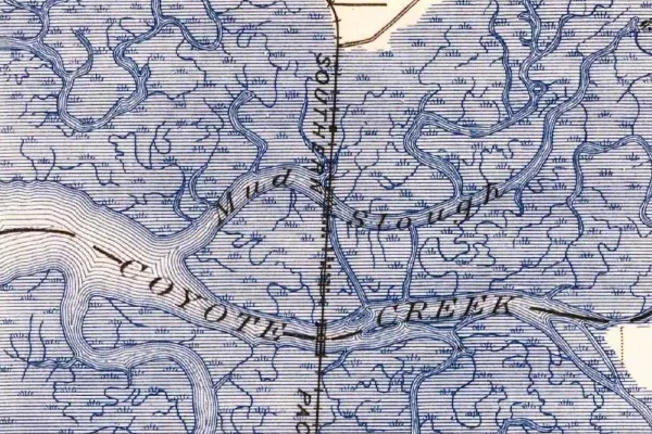
Drawbridge on the old USGS survey, and what the record holds around it
Within five miles the record maps 7 mine shafts, adits and prospect pits, 10 named mineral sites, 11 lost places and 3 cemeteries. Pro puts them on the map with the 1879–1919 survey underneath and a swipe to today.
From the archives
Drawbridge turns up on 7,138 digitized newspaper pages from California — read them free in the Library of Congress's Chronicling America collection.
Source: Library of Congress digital collections.
Questions from the field
- Can you walk to Drawbridge?
- No — the island sits in a closed area of a national wildlife refuge, and the only land route is an active rail bridge where trespassers have been killed. Legal views are from refuge levees or the train.
From the field
The most valuable part of this record is the part only visitors can write.
Stamp your passport
Check in at Drawbridge — GPS-verified visits earn an inked stamp.
File a field report
Road conditions, what's still standing, what's gone — your report joins the record.
Add photographs
Credited, dated, and preserved as part of Drawbridge's permanent record.
No field reports yet — sign in to file the first.
Primary sources for this record
- — USGS GNIS feature 1658437
- — U.S. Fish & Wildlife Service — Don Edwards SFB NWR
- — South Bay historical accounts (Drawbridge oral histories)