The story
Kaymoor was an unusual coal operation: two complete camps for a single mine. The Low Moor Iron Company opened the works in 1899 to feed its Virginia blast furnaces, naming the town for James Kay, the man who built it. Kaymoor Top sat on the rim of the New River Gorge; Kaymoor Bottom lay hundreds of feet below at the river. There were no churches or saloons here — just company stores, schools, the mine, and the coke ovens.
The two halves were linked by a steep haulage incline and, for the miners on foot, a long wooden staircase. At its peak the mine employed more than 800 men, many of them immigrants and African Americans, and over 62 years it produced nearly 17 million tons of coal — an exceptionally long life for a coal town, most of which lasted only a couple of decades.
The seam gave out and postwar demand slumped; Kaymoor Bottom was abandoned by 1952, a 1960 fire took most of what remained, and the mine closed for good in 1962. Today the ruins are reached by the Kaymoor Miners Trail, whose final descent is a staircase of 821 steps down to the coke ovens and the shell of the processing plant.
What remains today
The coal-processing plant ruins, a long row of coke ovens, the mine portal and haulage incline, and the 821-step miners' staircase, in New River Gorge National Park.
Society Pro
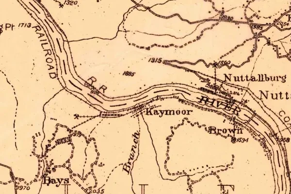
Kaymoor on the old USGS survey, and what the record holds around it
Within five miles the record maps 78 mine shafts, adits and prospect pits, 0 named mineral sites, 23 lost places and 5 cemeteries. Pro puts them on the map with the 1879–1919 survey underneath and a swipe to today.
From the archives

Kaymoor turns up on 82 digitized newspaper pages from West Virginia — read them free in the Library of Congress's Chronicling America collection.
Source: Library of Congress digital collections.
Questions from the field
- How many steps are on the Kaymoor Miners Trail?
- 821 — a wooden staircase descending the gorge wall from the upper haulage to Kaymoor Bottom, where the coke ovens and processing-plant ruins stand.
From the field
The most valuable part of this record is the part only visitors can write.
Stamp your passport
Check in at Kaymoor — GPS-verified visits earn an inked stamp.
File a field report
Road conditions, what's still standing, what's gone — your report joins the record.
Add photographs
Credited, dated, and preserved as part of Kaymoor's permanent record.
No field reports yet — sign in to file the first.
Primary sources for this record
- — USGS GNIS feature 1554851
- — National Park Service — New River Gorge, Kaymoor
- — National Register of Historic Places — Kay Moor Historic District