The story
St. Deroin was born on the Missouri River in 1854, a trading town named for Joseph Deroin, the Métis son of a French-Canadian trapper and an Otoe mother, who ran a trading post to serve the nearby Nemaha Half-Breed Reservation. Its lifeblood was a ferry that carried travelers across the river from Iowa for more than thirty years, and around the crossing grew a river town of a few hundred people below the bluffs.
The river that made the town also unmade it. The Missouri shifted its channel, ending the ferry and moving the crossing upstream to Brownville by 1915, and repeated flooding tore at the low townsite. A railroad spur bypassed St. Deroin as well, drawing off what trade remained, and the town was abandoned by around 1920.
The site now lies at the northern edge of Indian Cave State Park. The cemetery and a reconstructed one-room schoolhouse and store sit on the bluff above the vanished town, where the park sometimes staffs them with costumed interpreters bringing the old river settlement back for a day.
What remains today
The St. Deroin cemetery on the bluff, plus a reconstructed schoolhouse and general store used for living-history programs in Indian Cave State Park.
Society Pro
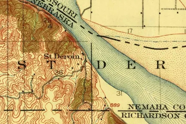
St. Deroin on the old USGS survey, and what the record holds around it
Within five miles the record maps 4 mine shafts, adits and prospect pits, 1 named mineral sites, 8 lost places and 6 cemeteries. Pro puts them on the map with the 1879–1919 survey underneath and a swipe to today.
From the archives
St. Deroin turns up on 122 digitized newspaper pages from Nebraska — read them free in the Library of Congress's Chronicling America collection.
Source: Library of Congress digital collections.
Questions from the field
- Who was St. Deroin, Nebraska named for?
- Joseph Deroin, a Métis trader — son of a French-Canadian trapper and an Otoe woman — who ran a trading post there in the 1850s to serve the Nemaha Half-Breed Reservation.
From the field
The most valuable part of this record is the part only visitors can write.
Stamp your passport
Check in at St. Deroin — GPS-verified visits earn an inked stamp.
File a field report
Road conditions, what's still standing, what's gone — your report joins the record.
Add photographs
Credited, dated, and preserved as part of St. Deroin's permanent record.
No field reports yet — sign in to file the first.
Primary sources for this record
- — USGS GNIS feature 1883771
- — Wikipedia — St. Deroin, Nebraska
- — Nebraska Game and Parks — Indian Cave State Park