The story
Animas Forks sits at 11,200 feet where three forks of the Animas River meet — one of the highest true towns ever attempted in the United States. Founded in 1873, it served the silver mines of the upper San Juans and at its peak held about 450 hardy souls, a hotel, a general store, and its own newspaper, which billed itself the highest in the world.
Winter defined everything. Snow could bury the town for months — the winter of 1884 reportedly kept residents tunneling between buildings for weeks — and most of the population migrated down to Silverton every fall. The great Gold Prince Mill, built in 1904, kept the town alive past the silver crash, but when it closed in 1910 and its machinery was salvaged, Animas Forks emptied for good within a decade.
About a dozen structures survive, stabilized by San Juan County and the BLM, including the famous Duncan house with its bay window looking down-valley. It's now the signature stop on the Alpine Loop.
What remains today
Roughly a dozen stabilized buildings — the Duncan house, the jail, the Columbus Mill foundations — with interpretive signs, in an alpine basin.
Society Pro
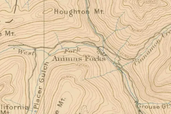
Animas Forks on the old USGS survey, and what the record holds around it
Within five miles the record maps 3,565 mine shafts, adits and prospect pits, 326 named mineral sites, 1 lost places and 0 cemeteries. Pro puts them on the map with the 1879–1919 survey underneath and a swipe to today.
From the archives
Animas Forks turns up on 2,786 digitized newspaper pages from Colorado — read them free in the Library of Congress's Chronicling America collection.
Source: Library of Congress digital collections.
Questions from the field
- Can a regular car reach Animas Forks?
- In good summer conditions a careful driver in a high-clearance vehicle makes it from Silverton; low-slung passenger cars shouldn't try. Most visitors come by 4WD or OHV on the Alpine Loop.
- When is Animas Forks accessible?
- Roughly late May to mid-October. The rest of the year the basin is snowed in — historically the whole town moved to Silverton for winter.
From the field
The most valuable part of this record is the part only visitors can write.
Stamp your passport
Check in at Animas Forks — GPS-verified visits earn an inked stamp.
File a field report
Road conditions, what's still standing, what's gone — your report joins the record.
Add photographs
Credited, dated, and preserved as part of Animas Forks's permanent record.
No field reports yet — sign in to file the first.
Primary sources for this record
- — USGS GNIS feature 187373
- — BLM — Alpine Loop Back Country Byway
- — San Juan County Historical Society